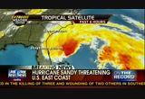
the major concern is that sandy will merge with two other storm systems becoming kind of superstorms. and sandy is set to strike a week before election day, power outages could pose some serious problems. >>> let's turn things over to jeff ranieri for his analysis. >> this storm system could be histor nick many respects. it's a category 1 storm but has tropical storm force rain bands stretching out some 400 miles from the center. usually see that with a category 2 or category 3 storm. so where does this storm track take us? as we head throughout sunday morning, it's going to be parallel to the carolinas. then by monday night, parallel to the mid-atlantic and then as we head throughout tuesday morning, our best guess right now would be a landfall here somewhere between new york and also washington, d.c. but a slight shift in the track to the north or south and it could mean drastically different conditions. so this, by all accounts, is an extremely dangerous storm system that anyone in the east coast or it you are doing anything traveling will need to watch closely. the wafrainfall, 6
 Live Music Archive
 Librivox Free Audio
 Metropolitan Museum
 Cleveland Museum of Art
 Internet Arcade
 Console Living Room
 Books to Borrow
 Open Library
 TV News
 Understanding 9/11